News
New London Climate Risk Mapping
Posted on 17/03/21 by Kristen Guida
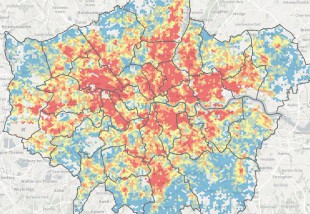
The GLA has released a new mapping tool to analyse climate exposure and vulnerability across London. These maps were produced by Bloomberg Associates in collaboration with the GLA and with input from LCCP partners.
The purpose is to help the GLA and other London-based organisations deliver equitable responses to the impacts of climate change and target resources to support communities at highest risk. The maps overlay key metrics to identify areas of the city that are most exposed to climate impacts with high concentrations of vulnerable populations. The metrics are aggregated to the hexagonal grid and presented as three map series: Overall Climate Risk, Flood Risk, and Heat Risk. A methodology report is also linked and recommended reading.