Flooding
London is prone to flooding from five sources – tidal, fluvial (from rivers and tributaries), surface (from rainfall), sewer and groundwater flooding. Climate change will bring wetter winters and throughout the year, more frequent heavy downpours, as well as rising sea levels and higher tidal surges.

One of the key steps to ensure London is better prepared for flooding is to be aware of the flooding risks London faces. LCCP partner London Councils explain the risks in this video:
Fifteen per cent of London is in flood plain, protected by flood defences. As well as people’s homes, within this area lies much of the infrastructure we rely upon day to day and to assist us in emergency, including 49 railway stations, 75 underground stations and 10 hospitals.
Much of this area is well defended, but the western end of the Thames and many of the tributaries to the Thames have low standards of protection. These are also the areas where we are seeing pressure to change both land uses, from industrial to residential and to increase the density of development.
Undertaking Strategic or Site Flood Risk Assessments is vital for Local Authorities and developments to apply a risk-based approach to development plans and implement actions.
But flood defences can only protect London from fluvial and tidal flood risk. The city is still vulnerable to surface water and sewer flooding from storm and heavy rainfall events. This is due to the large areas of impermeable surfacing (such as roads, roofs and pavements) and the legacy of Victorian drainage systems that aren’t equipped to cope. Events of this type are likely to increase in future, with the climate projections predicting more frequent intense rainfall.
Adaptation such as green space, green roofs, permeable surfacing, sustainable drainage systems, and resistant and resilient development, are essential for reducing London’s flood risk. Below is a more detailed summary of the sources of flooding across London.
Surface Water
This is the biggest risk facing London. Flash flooding happens when rain falls so fast that the underlying ground cannot cope, or drain it away fast enough. Roads can become like rivers and if there is a lot of water, it can flood buildings and carry cars away. It can occur very quickly and without much warning.
London is particularly vulnerable to flash flooding from heavy rainfall events. This is due to the large areas of area which is impermeable (such as roads, roofs and pavements) causing water to run off it quickly rather than more permeable surface where it can soak into the ground. There is also the legacy of Victorian drainage systems that take away water from the roads, that doesn’t have the capacity for the or is able to cope with the intensity of rainfall. Climate projections predicting more frequent intense rainfall will increase this risk.
Find out more about how London is tackling surface water flood risk in our summary note:
Tackling surface water flood risk
Sewer
Sewer flooding occurs where foul or combined sewers become blocked or overloaded. This tends to impact properties or places connected to the sewer system located at a level below the hydraulic level of the sewage flow. Other issue can occur when supply pipes burst.
In most of central and inner London the surface water and sewerage networks are combined in “Combined Sewers”. So when there is heavy rainfall this can often result in what is known as combined sewer overflows (CSO) into rivers.
Overview Map of London Sewers – system and purpose.
Find out more about how London is tackling sewer and reservoir flood risk in our summary note:
Tackling sewer and reservoir flood risk
Waterways
There are many large “main” rivers and smaller “ordinary” watercourses as well as Canals forming a blue network throughout London.
Find out more about how London is tackling river flood risk in our summary note:
Tidal
The River Thames and the lower reaches of some of the tributary rivers are affected by the tide. The River Thames has a very large tidal range, in excess of 7 metres on spring tides. The tide’s influence reaches to Teddington Lock on the Thames and up several tributaries, for example as far as Lea Bridge on the River Lee.
As a result of the 1953 flood, a system of flood defences was constructed. The most iconic element of this is the Thames Barrier, which has been operational since 1982. There are also around 400 smaller barriers and movable flood gates downstream of the Thames Barrier and over 300 km of river walls and embankments stretching into Essex and Kent that have been raised by up to 2 metres to give additional protection from storm surges. Upstream of the Thames Barrier, river walls are still necessary to prevent the normal range of high tides from flooding parts of inner and central London.
This system of tidal flood defences made allowance for sea level rise and London is therefore protected to a very high level. Without the current river walls many areas of London alongside the Thames and along the tidal stretches of the tributaries would be inundated twice a day through the normal tidal cycle. River walls have been steadily built up since Roman times to give increasing levels of flood protection and to enable urban development.
Find out more about how London is tackling tidal flood risk in our summary note:
Groundwater
Flooding from groundwater can happen when the level of water within the rock or soil that makes up the land surface (known as the water table) rises. This flooding happens slowly over months. The Environment Agency supply information in the form of monitored groundwater levels. In parts of Croydon and South London which has historically experienced groundwater flooding, the Environment Agency provide a groundwater alert or warning service. Further information on the groundwater risks status can be found South London: groundwater situation – GOV.UK (www.gov.uk).
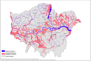
MAP of Increased potential for elevated Groundwater from the Regional Flood Risk Appraisal 2018.
London Flood Awareness Week event – Dec 2022
As part of London Flood Awareness week 2022, the LCCP partnered with the Greater London Authority to host an industry focussed event to share good practice and discuss how to make London more resilient to surface water flood risk now and in the future.
The event, in London’s City Hall, featured speakers from across the water management and climate sector, including the Met Office, Borough representatives, the Greater London Authority, the Environment Agency, Thames Water and the National Flood Forum.
For more details of the speakers and to download the presentations please see our events page.
Although climate projections suggest that London’s summers will become drier, heavy downpours are still expected to become more intense. Without an increase in resilience, London could suffer more severe surface water flooding, with greater risks to lives and livelihoods.
While there has been understandable focus on learning the lessons from the flood events of 2021 work has also begun on a much needed long-term surface water flooding strategy for London that takes account how climate change is affecting the probability of heavy rainfall. The LCCP will continue its involvement and support throughout 2023 and beyond for this important piece of work. More details on this will be released in due course.
Be prepared for flooding
You can identify if your home is at risk of tidal or fluvial flooding at The Environment Agency’s website. The Environment Agency also provides a free Flood Warning service, for those who live in areas of risk.